This past summer, as David Salisbury flew into the Peruvian Amazon, he looked down at the lush canopy of the forest below.
From this vantage point, he could see the vast rainforest — an intricate ecosystem of trees and rivers, sloths and monkeys and poison dart frogs, 40,000 plant species and 33 million people.
It’s a landscape he knows intimately after two decades traveling to the Peruvian-Brazilian borderlands. Alongside his students, he’s mapped rainforest changes from illegal roads, mining, logging, and climate change.
After his five-seat plane descended onto a strip of grass in the Ashéninka village of Dulce Gloria, he wound his way downriver into Brazil, then back up a creek and across the border again to a remote village in Peru.
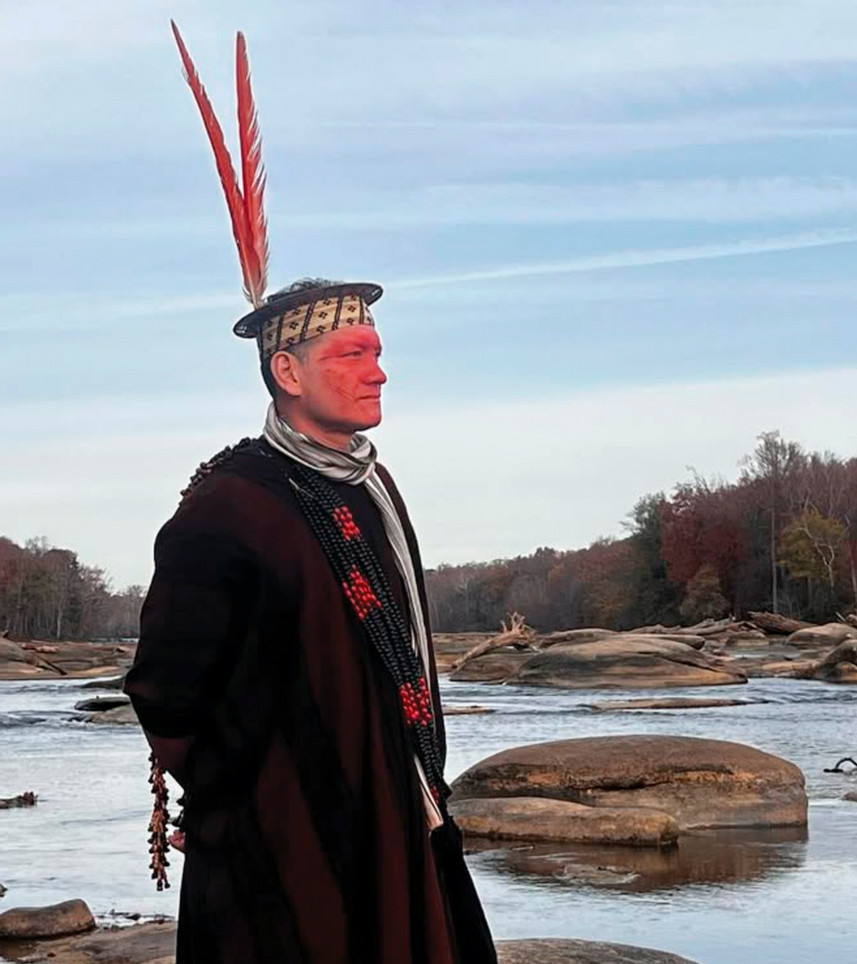
Wewito Piyãko, leader of a Brazilian Amazonian community, at the James River during a 2023 visit.
That’s where he met Maria Elena Paredes Márquez, chief of the Sawawo Hito 40 community, which was hosting a meeting of Indigenous leaders called the Transboundary Commission. Also in attendance were Wewito Piyãko, a filmmaker and president of the Apiwtxa in neighboring Brazil, and Cazuza Borges, a member of the commission’s technical team.
Salisbury has known Márquez and Piyãko for more than a decade and worked with Borges for 25 years. Now, they’re partners on the Amazon Borderlands Spatial Analysis Team, or ABSAT — a knowledge exchange where researchers capture geospatial and satellite data on climate change, and Indigenous people share the impact of environmental changes on their lives.
These lived experiences add a personal layer to Salisbury’s data. In turn, Salisbury helps Márquez, Piyãko, and other Indigenous people use that data to protect their ancestral lands.
“I never wanted this to be a solo project,” Salisbury said. “I didn’t want to be some gringo who drops out of the sky and then disappears for the rest of my career.”
Mapping change
The ABSAT project began as a partnership between Salisbury, chair of the department of geography, environment, and sustainability, and Stephanie Spera, an associate professor in the department.
Both began researching in South America while in graduate school before they knew each other. Salisbury traveled by helicopter, on rivers, and along trails to help map a proposed national park. Spera used satellite data to analyze the effects of land use and climate change in Brazil’s Cerrado, or backcountry.
After Spera was hired by the university in 2018, she found a NASA-SERVIR Amazonia grant and approached Salisbury about a collaborative project that would build on their experience and relationships in the region. They received a three-year, $700,000 grant.
“I’m good at taking the satellite data and doing big data analysis, but the outreach component was new to me,” Spera said. “David has a history of boots on the ground, going out in boats and sleeping in tents to get to places where he can talk to people.”
ABSAT studies how forest degradation, deforestation, and road construction affect the ecosystem in the Southwestern Amazon — and provides tools to locals who want to protect it.
“We want these communities to have a stronger footing to make their case for keeping their culture and their environment intact,” Spera said.
“Community experts bring deep contextual knowledge that provides richness and nuance to research projects and teaching opportunities.”
The grant also funded a postdoctoral researcher and undergraduate assistants. Delaney Demaret, ’24, first traveled to Peru in 2022 for a weeklong workshop led by Salisbury and Spera with NASA researchers, local university representatives, Indigenous leaders, and NGO partners. Together, they identified key indicators for measuring land-use changes and climate impacts — temperature, precipitation, soil moisture, stream height, and relative humidity — which Salisbury and students later collected.
Now a master’s student at the University of Oxford, Demaret returned this summer to conduct fieldwork for her dissertation, guided by Salisbury.
“We went downriver, community by community, doing mapping workshops with the Transboundary Commission,” Demaret said. “It was cool to do such intense fieldwork. You know what you’re doing has an impact almost immediately.”
ABSAT’s student researchers created about 700 community maps for Indigenous and protected area partners showing the impacts of deforestation and forest degradation.
“Those maps helped our Indigenous partners visualize things they already knew because they live and work in the forest and the fields,” Salisbury said.
ABSAT then partnered with Indigenous leaders, local universities, and NGOs to use that data to address environmental challenges. Jasmine Lin, ’27, traveled to Peru last summer to present ABSAT data at commission meetings. While there, Lin watched as Indigenous leaders and conservation experts described the lives playing out on her maps.
“We often think of research as, ‘I have this question in mind and I’m going to publish a paper about it,’” Lin said. “But with ABSAT, we didn’t just listen to what the scholars were saying; we heard people put the problem in context in their own language.”
Close to home
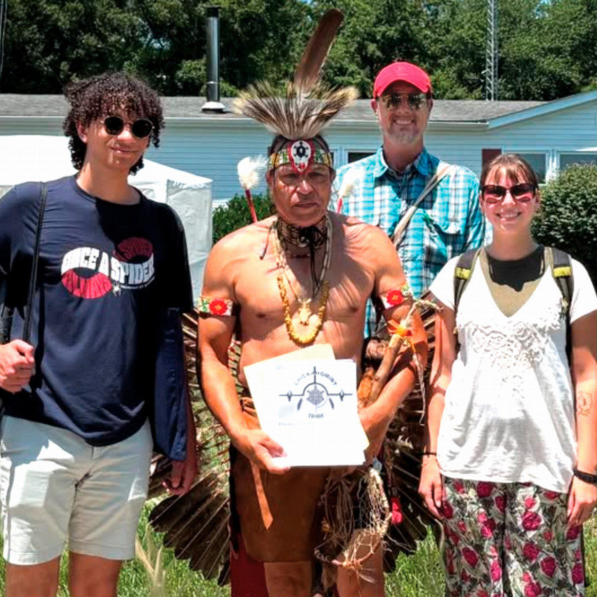
LILT students Gus Dulaney-Dewald and Lily Greisch with David Salisbury, back, and Chickahominy tribesman Preston Adkins
This past summer, as some Richmond students were touching down in the Amazon, two others — Gus Dulaney-Dewald, ’27, and Lily Greisch, ’27 — were busy making their own maps. Like their counterparts, Dulaney-Dewald and Greisch were examining how climate change affects Indigenous people, such as how increased flooding impacts access to traditional food sources.
“We spent a lot of time parsing environmental data that’s publicly available through the National Oceanic and Atmospheric Administration,” Dulaney-Dewald said. “We were compiling it, running analyses on programs such as ArcGIS, and then communicating with tribal officials.”
But unlike ABSAT, they’re focused on their own backyard.
Dulaney-Dewald and Greisch are part of the Local Indigenous Landscapes Team. The project is modeled after ABSAT but focuses on Indigenous tribes in Virginia. Among their leaders is Keith Anderson, R’89, principal chief of the Nansemond Indian Nation.
In addition to examining the impacts of sea-level rise in the Chesapeake Bay and along the James River, LILT created story maps that document the history, culture, and contemporary status of Virginia’s 11 tribes. They presented Nansemond maps to Anderson in August and to the Chickahominy Tribe in September.
“The story maps were to make sure that we, as researchers, understand what we were going into and who we were going to be collaborating with,” Greisch said. “It showed that we were willing to listen and open to learning. We weren’t just saying, ‘Let me help you, for my own sake.’”
Dulaney-Dewald said the process was a chance to learn the nuances of telling another’s story and enabling them to tell their own. “When we’re working with the tribes, we consult with them on what we research and what we write,” he said, “because ultimately, it’s their story.”
Worlds collide
In the fall of 2023, Márquez and Piyãko traveled by boat and plane through the Amazon and across the U.S. They arrived in Washington, D.C., where they met Salisbury and boarded a train bound for Richmond.
During a presentation for International Education Week, Piyãko spoke about the changes he saw in his community.
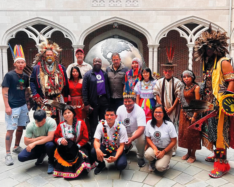
Indigenous leaders from the Amazon and Virginia on campus in 2024.
“This summer has been the hottest ever. The waters are like coffee. The fish are dying,” he said, with Salisbury serving as translator.
But he and Márquez also had a chance, for the first time, to explore Salisbury’s home, accompanied by members of the Indigenous tribes who have lived along the James River for generations.
The following year, Salisbury helped bring another group of young Indigenous leaders from the Peruvian Amazon and the Andes, this time through a State Department program. Salisbury invited his students and Anderson to a gathering, hoping to continue strengthening the ties between the communities he’d known for decades and the ones he was just beginning to understand.
Salisbury asked Anderson and his son to demonstrate a Nansemond dance, hoping others would organically follow suit. He watched as the Amazonians jumped in, followed by the Richmond students. The crowd seamlessly shifted from Indigenous movements to rhythmic salsa to country line dances. By the end, everyone joined hands, snaking across the room as one body.
“This is exactly what we want. To make this connection between UR, the Amazon, and Virginia. To see people sharing culture, sharing movement, building camaraderie,” Salisbury said. “I couldn’t stop smiling.”
Kim Catley is a freelance writer based in the Richmond area and a former staff member of University Communications. Additional reporting was contributed by Rayne Miller and Matthew Dewald.
Photographs courtesy of David Salisbury, LILT, and ABSAT (top to bottom)